About SkyDemon
SkyDemon is Europe's favourite software for VFR flight planning and in-flight navigation. Use this app to access your SkyDemon subscription on your iOS device, unlocking SkyDemon's powerful features while on the move. FLIG
SkyDemon is Europe's favourite software for VFR flight planning and in-flight navigation.
Use this app to access your SkyDemon subscription on your iOS device, unlocking SkyDemon's powerful features while on the move.
FLIGHT PLANNING FEATURES
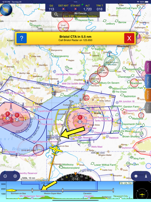
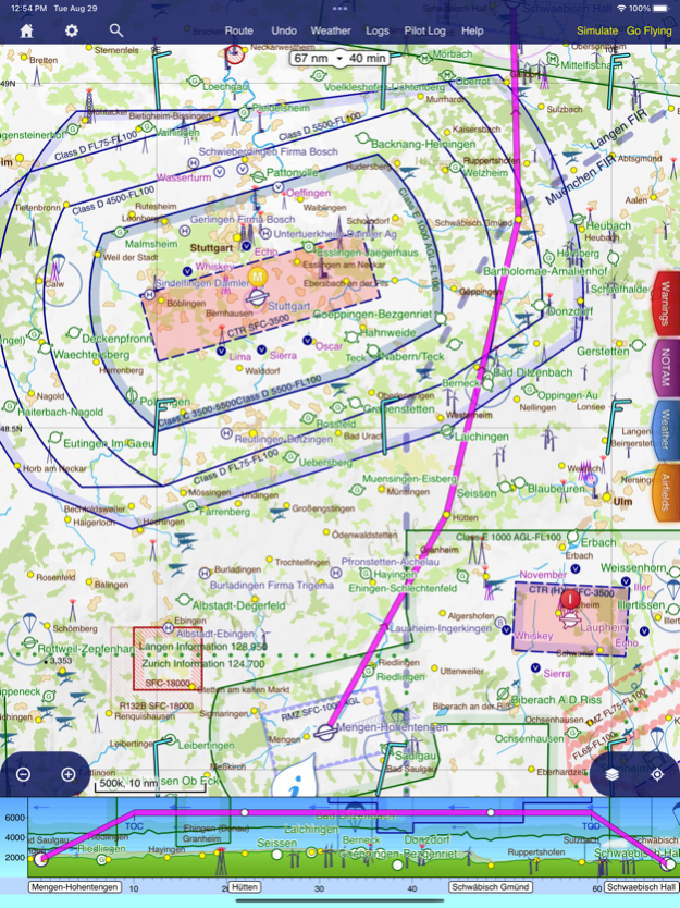
- SkyDemon vector charts are the clearest aeronautical charts you'll ever use, with dynamic airspace clipping and choice of map layers
- Route planning is as simple as touching consecutive waypoints and dragging to make changes
- Virtual Radar shows how your route relates to airspace, terrain, obstructions and other features
- Pilot Log facility calculates headings and groundspeeds from actual wind data, and shows useful frequencies
- Plates and other documents for relevant airfields are displayed automatically as you plan, and many are available georeferenced for use in flight
- Intuitive pan, pinch and rotate support with no loss of map clarity or text legibility
- File a VFR flightplan for your route directly to air traffic controllers
- Automatic TAF, METAR and SIGMET briefing as you plan a route, with graphical decoding
- Rainfall data can be overlaid on the main map, with animation, showing the trend of rainfall over time
- Integration of GAFOR route forecasts for Switzerland, Austria, Slovenia and Croatia
- Both narrow-route and area NOTAM briefings available, updated as you plan
- Advanced NOTAM graphical interpretation and depiction on the main map
- Easily print your PLOG and the output from various briefings
- Warnings for airspace and other potential hazards to your flight, updated in real time
- Airfield Admin Information shows useful contacts and other details for airfields featured in our charts
- Forecast winds aloft are automatically retrieved for the flight time and displayed on the map
- Create an advanced flight performance profile for each aircraft you use
- ATS Routes mode offers an alternative chart presentation for flight along airways
- Accurate fuel, weight and balance calculations including flight costings
- Create an unlimited number of user-defined waypoints
- Analyse your track logs for posterity
- Choose between six different vector chart styles
- Extensive European chart coverage as standard
GPS NAVIGATION FEATURES
- Intelligent warnings for approaching airspace, NOTAM, obstacles, terrain and other hazards
- Virtual Radar shows a side-on projection of all approaching features and how your trajectory relates to them
- Vector map automatically follows the aircraft in north up, track up or course up orientation
- Clear and concise instruments show you flight statistics and help keep you on track
- An HSI/ILS instrument helps you keep to your planned route and line up early for approach
- Live Pilot Log shows progress through your route, ETAs, ATAs and useful frequencies based on your current position
- TerrainSafe dynamically colours mountainous terrain around you to quickly identify safer areas
- Direct To allows easy re-routing in a hurry by picking from a selection of nearby airfields
- Approach Information shows runway diagrams, TAF, METAR, NOTAM and other airfield details useful for making an approach
- Live updates of TAF and METAR while in flight, with associated alerts*
- Extended runway centrelines appear automatically on the map as you near your destination airfield
- Permanent display of position relative to nearest well-known waypoint, for position reporting
- Easy changing of the planned route while in flight by touching and dragging
Continued use of GPS running in the background can dramatically decrease battery life.
* Internet connection required for live weather update while in flight
Apr 1, 2024
Version 3.16.13
- The new Explore Heatmap tool allows you to create and explore heatmaps from all your logged flights
- Many improvements to memory consumption, speed of loading data and speed of drawing maps
Previous Versions
Here you can find the changelog of SkyDemon since it was posted on our website on 2016-10-03 00:38:08.
The latest version is 3.16.13 and it was updated on 2024-04-19 17:06:50. See below the changes in each version.
SkyDemon version 3.16.13
Updated At: 2024-04-01
Changes: Apr 1, 2024
Version 3.16.13
- The new Explore Heatmap tool allows you to create and explore heatmaps from all your logged flights
- Many improvements to memory consumption, speed of loading data and speed of drawing maps
SkyDemon version 3.16.12
Updated At: 2024-02-12
Changes: Feb 12, 2024
Version 3.16.12
- Improvements to the High Contrast / Night chart style
- Improvements to performance while updating charts
SkyDemon version 3.16.11
Updated At: 2023-12-10
Changes: Dec 10, 2023
Version 3.16.11
- You can now customise the trail left by your aircraft in flight
SkyDemon version 3.16.10
Updated At: 2023-09-24
Changes: Sep 24, 2023
Version 3.16.10
- FIS boundaries are now drawn in our maps
- International borders are now highlighted in our maps
- Airspace activations by NOTAM and AUP are listed in the What's Here screen for the airspace
SkyDemon version 3.16.9
Updated At: 2023-06-11
Changes: Jun 11, 2023
Version 3.16.9
- Terrain shading and colours have been updated to look better across Europe
- A list of recent finds is kept in the Search window
- You can now tap the wind in What's Here to see winds aloft at all altitudes
- Improvements to graphical NOTAM depiction in Eastern Europe
- The aircraft CG envelope can now be defined as a moment-mass graph
SkyDemon version 3.16.8
Updated At: 2023-05-04
Changes: May 4, 2023
Version 3.16.8
- GFP file format is now included when you share a route, for Garmin GTN devices
- Virtual Radar has been updated so that while flying, more terrain below you is visible
- A sound and speech is now played if you lose the connection to your WiFi traffic receiver
SkyDemon version 3.16.7
Updated At: 2023-03-28
Changes: Mar 28, 2023
Version 3.16.7
- Improvements to map drawing speed
- Various minor user interface improvements
SkyDemon version 3.16.3
Updated At: 2022-05-23
Changes: May 23, 2022 Version 3.16.3
- Direct To Overhauled
- Waypoint Searches in Flight Sorted by Proximity
- Previous and Next Buttons in Logs
SkyDemon version 3.16.2
Updated At: 2022-04-10
Changes: Apr 10, 2022 Version 3.16.2
- Sharing a route now produces files in GPX and FPL formats along with the SkyDemon format
- Scratchpad now supports Apple Pencil and a variety of drawing tools
- Improved the chart loading speed
SkyDemon version 3.16.1
Updated At: 2022-03-20
Changes: Mar 20, 2022 Version 3.16.1
- Fixed a bug concerning logging multiple takeoffs and landings within one flight